Category Archives: Art

The Circle of Formation.

Tracking agroforest tree plantings and farm features using QGIS

Asked how tree crop enthusiasts are keeping track of plantings and related info, I shared this info:

Metal tree tags on locust stakes are low-tech and work reliably. Next best is grease-pen or indentations on metal or vynil tags, attached to trees themselves. Overall, it’s great to be pro at plant ID, but that doesn’t always work to differentiate between cultivars.

For a more advanced, digital approach, I use QGIS. It offers the benefits described in a comment above about ArcMap, but it is free and open-source software. It has a little bit of a learning curve, but it is a very powerful tool and it can interface with other geospatial technology including GPS, Google Earth, and iNaturalist. Google Earth has an easier learning curve and has more than enough features for most users. If you want to go the QGIS route, I recommend trying the following steps to begin with, and feel free to ask questions in the comments or on gis.stackexchange.com.

  1. Install (and if you can, make a contribution to) QGIS https://www.qgis.org/en/site/.
  2. Find and download raster files (.jpg, .tif) for overhead views of your Area of Interest (AOI). These files are referred to as aerial imagery or orthoimagery, and in the U.S. you can get them from county GIS websites or from https://nationalmap.gov.
  3. Follow a basic tutorial about raster vs. vector file types, and creating shapefiles.
  4. Create a polygon shapefile for your AOI boundary- Create a point shapefile for your individual plants.
  5. Add new attribute fields to your ‘plant points’ shapefile to describe characteristics you want to keep track of. Here’s some fields I use (+ examples/explanation):
    • species (corylus spp.),
    • planted_date (fall 2019),
    • permanent (y/n in case it is to be transplanted),
    • measured (y/n to indicate if its location is precise or estimated),
    • source (to keep track of cultivars, purchases, etc),
    • updated (date for when this entry was last updated, since inevitably the records can get out of date; update this every time you update any other field for this data row)
    • notes (misc info that doesn’t fit cleanly in other fields, try to use this sparingly as it is better to have distinct fields in case later on you want to select or analyze plants based on some attribute)
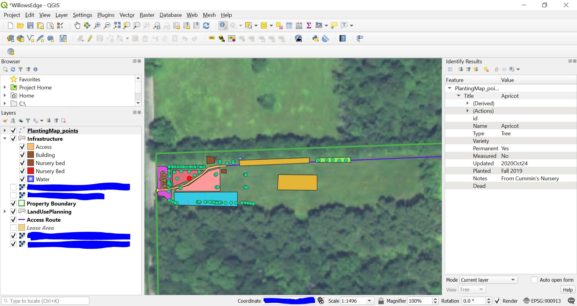
Screenshot of QGIS in use for agroforestry mapping
Here’s what QGIS looks like in regular use for me. You can add shapes as points, lines, or polygons, which can represent individuals, linear plantings, or orchard blocks. This screenshot shows an individual tree point selected, with the kind of info I described above and more displayed on the right-side ‘attribute table’.

At this stage, you will have a powerful, interactive map of your AOI, with individual points or polygons to depict features of interest on your property, and those features can have a miniature (or massive) database of characteristics associated with them. You can have as many or as few fields as you’d like, and you can even associate fields (e.g. feature_ID) with other datasets, such as yield records or amendment history for an orchard block.

In practice, as I plant or inspect plantings, I jot notes in text messages to myself or on a muddy piece of paper, and then I digitize those notes by updating my QGIS project for the plantings. A text might be as cryptic as “purp os willow x4 3′ e of ne hazels” and I use those notes to enter four purple osier willows planted at 3-foot spacing starting east of the northeast hazelnut hedge. As long as I don’t wait too long between field notes and digitizing, it works well enough, and this could be much more precise if I wanted to take the time to GPS-locate each planting.

Lastly, if you are just getting started with GIS tools, I suggest exploring a basic tutorial about Coordinate Reference Systems (CRS) and about Georeferencing. That will help you get ahead of GIS software’s more confusing aspects, which many people don’t learn about until they are tangled in problems with coordinate systems. Using a CRS appropriate for your region and consistent for all layers in your project will help you avoid problems and make accurate spatial measurements and maps. Again feel free to drop questions in comments or visit the very helpful gis.stackexchange.com.
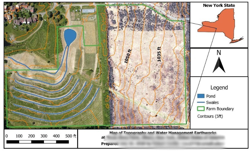
Example map from QGIS
Here’s a finished map from QGIS. It is not as easy to make proper maps in QGIS but it is possible – a tutorial will save you a ton of time vs. winging it.

We are all in this together: balancing individuality and oneness amidst evolving mainstream metaphysics

Importantly, the universe being a simulation does not imply solopsism.

I have seen a few cases of solopsism and similar philosophies taken as a given, based on the ‘universe is a simulation’ press circulating. Eventually news will spread that theoretical physicists think of mind as a substrate of reality. What philosophies will people be drawn to while digesting that revelation?

It is important to remember that in any of these metaphysical views, it can still be true (and perhaps much more-so) that we are all in it together.
Perhaps I am just an ant, or just dust, or just digital. And so, I know how much an ant, or dust, or digital bits, can suffer, aspire, inspire, and love.

May peace be upon you!

Storied Pasts

https://www.lionsroar.com/magical-emanations-the-unexpected-lives-of-western-tulkus/

“If I died in a month would I be satisfied with my life, and the answer was ‘no’.”

“I don’t have to be a reincarnation. It’s not the most important thing. If my existence has meaning, it’s because I’m doing good in this world—I’m helping people. I don’t have to be a tulku in order to do that.”

“We don’t need all those complications,” he says. “We’re all humans. We’re all struggling. We’re all learning from each other.”

“Yesterday, I was talking to one of my tulku friends who is in New York, happily driving for Uber.”

Storied Selves

Highlights generously provided by a YT commenter:

– We are all unreliable narrators of our own lives.
– To tell a story is inescapably to take a moral stance.
– Stories are the way we make sense of our lives.
– The way we narrate our lives shapes what they become.
– Change, even really positive change, involves a surprising amount of loss.
– What would happen if you looked at your story and wrote it from another person’s point of view?
– Life is about choosing which stories to listen to, and which ones need an edit.
– There’s nothing more important to the quality of our lives than the stories we tell ourselves about them.

O Sol, InsPHIre I

Sunday: It is all about our unique individuality and what we do with it.

“All that survives of these solar hymns are an altered version of Proclus’ Hymn to the Sun, and the 9th hymn in the Nomoi … the Sun is ruler of the other planets, and with them governs all terrestrial things. …The theory of prayer with which Pletho introduces his hymn is remarkably like the theory of magic behind Ficino’s astrological music; Pletho addresses the gods thus:

‘May we carry out these rites in your honor in the most fitting manner, knowing that you have no need of anything whatever from us. But we are molding and stamping our own imagination and that part of us which is more akin to the divine, allowing it both to enjoy the godly and the beautiful and making our imagination tractable and obedient to that which is divine in us.’

Pletho’s hymns and rites, like Ficino’s do not aim at any objective effect on the deity addressed, but only at a subjective transformation of the worshiper, particularly his imagination.” -(p.61)

Spiritual and Demonic Magic from Ficino to Campanella by D.P. Walker

via Mark Stavish of the Institute for Hermetic Studies

What will come of this?

Year 2222
200 winters away
How many generations will have passed?
What will I&I enjoy in life? What of one's own ways will continue?
What lessons will I&I have learned?
What challenges will I&I face?

What will I&I have of the essential gifts to sustain oneself? Wood, water, air, soil, energy?

#TreesAreTheAnswer #WeAlreadyKnow #Hózhó

Visiting a neighbor’s fire

Though the work is easier together, we spread out in the darkest time of year to cozier burrows, diffusing the weight of winter, lighter on the land.
Though it is dark, we are warmed to know there are familiar others nearby. Our struggles are tied up together, and while one faces scarcity, someone else has more than enough to share, so that we may survive together and work together in brighter times.

So it has been through the ages. So it is still in little ways in overdeveloped places where big systems eclipse mutual aid: we turn to neighbors for power during long outages, for tool shares, for relationship. So it is still in big ways in underdeveloped places where small systems are made sufficient by human relationships: cooperating to cultivate land, to maintain infrastructure for basic needs, for relationship.

The lessons of the seasons proceed before us, though we may be distracted by a house on fire, our own or our neighbors.

May we be there for each other, so that we may all meet our needs, in mutual benefit with the sources of that sustenance and satisfaction. May peace be upon you.


Continue reading →

Quantum-classical connections: a great article on entangelement and decoherence at larger scales than quantum particles

I found this article helpful for understanding decoherence, as the diffusion of quantum entangelement from the complex inter-relations of particles. Thus why my body cannot be in superposition, as it would decohere at the scale of a microbe, nonetheless at the scale of an organ or whole body.

https://getpocket.com/explore/item/real-life-schrdinger-s-cats-probe-the-boundary-of-the-quantum-world